From the Mazomanie Historical Society
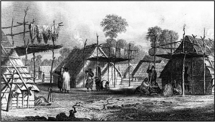
Mazomani--Where He Lived
Br Frank Wolf
The village of Mazomanie was named after the Wahpeton Dakota Sioux Indian leader named Mazomani. His name in the Siouan language means Walking Iron or Iron Walker. The village was named Mazomanie when it was platted on July 5, 1855.
Historical evidence shows that there were two chiefs named Mazomani or “He who Walks on Iron” or “Iron Walker.” They were father and son who lived at Little Rapids Village on the St. Peter River, now known as the Minnesota River.
Both Mazomanis lived at the Indian village called Little Rapids or Inyan Ceyaka Otonwe in the Dakota language. Little Rapids had been a place name for at least two centuries before 1850. In 1838 Joseph Nicollet referred to the site as Inyan Cheaka or barrier of stone. The village was located on the Minnesota River banks between present day Carver and Jordan, MN. It was two miles directly south of Carver and three miles directly north of Jordan. The site is in Sections 31 and 32 of Louisville Township in Scott County, 25 miles southwest of Minneapolis. This is in the Minnesota Valley National Wildlife Refuge’s Louisville Swamp Unit. The site is open to the public via a hiking trail of 4-1/2 miles long that will take one through the area. It is named the Mazomani Trail.
The rapids are in two sets, near a bend in the river. Major Stephan Long in 1823 described the rapids as: “… came to rapids formed by two bars of sandstone which extend across the river producing a fall of about four feet within 20 yards…” The two sets of rapids, near a bend in the river provided a strategic location for a village. The advantages to occupy the land around the rapids included the ability to control trade. Indians and fur traders canoeing the river would need to portage around the rapids. Beginning with the Woodland Indians, the site was occupied from approximately 500 AD. In 1802 near Little Rapids, a trading post was established. It was first operated by Jean Baptiste Faribault and two sons of the Machilimackinac Fur Company and the Northwest Fur Company. Over the next 45 years it was visited by fur traders, Dakota Indians and missionaries. In 1834 there was a Wahpeton village at present day Carver. An early map indicates this was at the mouth of Carver Creek. Further upstream two miles, adjacent to the rapids and trading post was another Wahpeton village. It was on the east side of the river as placed by archeological and eyewitness accounts. Visitors to the rapids in the 1830s and 1840s would have witnessed a busy location. Both the trading post and village were abandoned after 1851.
The village was a summer planting village, which would have been primarily occupied from late spring into fall. The site is a fairly flat grassy plain forty feet above the rapids and separated from them by a small marshy basin and flood plain forest known as Johnson’s Slough. Household bark lodges were scattered in the northern area of the site. The rectangular lodges with gabled roof were made of six square foot slabs of elm bark lashed to a wooden pole frame with basswood bark strips. The slabs were also placed on the roof lapped in a waterproof shingle fashion. House size depended on how many people lived in it. Earthen burial mounds cover the southern part of the site. There was a dance area, small corn field and community dump. The Indian mounds are the only current sign that a village may have once occupied the Scott County site. Over the years, the village site has been damaged by amateur archeologists, collectors and grave robbers seeking artifacts. In 1887, the twenty-nine burial mounds on the site were mapped. The Klammers investigated the site in the 1930s. More than 300 objects were found. In the 1980s, Archeologist and University of Minnesota Minneapolis Professor of Anthropology Janet Spector led a group of college archeologists and interested tribal members in a dig of the site. Their findings resulted in her book, “What This Awl Means.” In 1999, the thirteen-acre site was added to the National Register of Historic Places. The period of significance cited was from 500 to 1851. Mazomani was the significant person noted and he was affiliated with the Eastern Dakota and Woodland Cultures.